
Polaron is a subsidiary of Urban Hawk Ltd, a company focussing on spatial intelligence.
Whether it’s games or fusing complex spatial data to produce insight, Polaron is in reality one part of a larger set of capabilities and products. We are seeking to further develop the Polaron Engine and further develop Urban Hawk Ltd to support the development and exploitation of the IP into multiple different verticals.
Where we’ve come from
Developed over the past five years – Polaron combines an incredibly fast spatial database with a cutting edge simulation and big data capabilities to allow multi user real-time simulations.
Whilst you can even build 3D models in our tool and maintain them via real-time sensors, a lot of the time our users just want to get from A-B or test out a theory.
It’s important to frame that when we talk about real-time we mean anywhere between 30fps > 140fps on COTs hardware and at present the read-write speed is the largest constraint (as in the speed at which an external source can write into the solid state memory and be read and ingested into the CPU / GPU). This presents a lot of opportunities to scale up the size of scenes, to combine different scales and 2D & 3D and Spatio-Temporal data.
Where we’re going
Polaron offers that ability and the chance to validate ideas, consider, iterate and then measure them – as they impact a living digital twin. Whether this is making routes safer, a plan to save on costs, reduce environmental impact, or provide greater disabled access. Whilst seemingly diverse the technology is the same or very similar – just as a spreadsheet can be used for to-do lists or to-do lists or run whole companies we have a laundry list of capabilities that can benefit public transport.
We want to make the best and fastest spatial database we can – and then set our users loose on it so we can make it better.
We believe in an age of ubiquitous EOS data and open source information; its finally possible to realise the dream of having games routed in real world data.
We think spatially encoded data is the future and would like your help getting there.
What we’re seeking
Developed over the past five years – Polaron combines an incredibly fast spatial database with a cutting edge simulation and big data capabilities to allow multi user real-time simulations.
Whilst you can even build 3D models in our tool and maintain them via real-time sensors, a lot of the time our users just want to get from A-B or test out a theory.
To achieve this we need to raise capital (the more the better!) which affords us additional resources, decreases our time to market and allows us to expand our development team, engage further in Ai / ML and embrace marketing and the host of supporting functions we need to really see Polaron thrive.
We’re still very lean and plan to remain so – but with your help, connections and financing we can realise the dream of Polaron: for games, for analysis and digital twins – rooted in real-world data.
Investment opportunities
Invest in Urban Hawk Ltd
With overall ownership of the Polaron IP, we are seeking a significant investment into the proven business to support our growth and development.
Part of our roadmap is to support and engage in multiple overlapping or parallel verticals – allowing efficient development services for businesses and consumers
We are looking for Angel or Consortium investors that can bring not only capital but market connections to help boost the company’s development and growth. Ultimately Urban Hawk work on a broader range of functions.
What about Polaron?
A new company (working title – Polaron Ltd) will shortly be formed is focussed solely on the Simulation Software and dependent applications. Unlike Urban Hawk – this has a much narrower product based focus.
This allows the business to focus its energies and resources solely on building and refining the software product and supporting systems.
Polaron is the culmination of many years of work by Urban Hawk Ltd, and covers a range of interests, whereas Polaron is focussed on the Commercialisation of the Simulation engine.
There’s a reason Open Ai purchased a Voxel based world building company – and we believe Polaron’s supported level of interactions is unmatched on COTs hardware.
Invest in Gaming
We believe that the Voxel based simulation and the amount of data that can be packed into the engine, offers amazing opportunities for gaming.
Unlike other games engines, Polaron comes from a GIS and Analytical pedigree – meaning it is focussed on the interactions of different entities.
This allows amazing interactive gaming experiences. We will be releasing more details soon.
Interoperability
Part of the desire to seek further investment is to allow us to continue to focus on the core simulation product, whilst allowing other parts of the team to focus on interoperability and integrations – since this is the common pain point to adding and removing data.
Whilst the gaming pathway ultimately generates an intuitive user interface and we can already expose APIs and feeds in the system, we want to make this more robust to allow Polaron to become a platform and ultimately a marketplace.
REST APIs & Data feeds.
Allowing you to add and extract data from Polaron as well as issue instructions and controls – which permits a huge capability to automate and manage your simulations from existing tools, infrastructure and datasets
Database integrations & Interfaces
Whether relational or non-relational databases or even flat data files – we can import huge volumes of data at very high speed – then process that within Polaron to generate spatial and relational insights.
WebRTC interfaces & Mobile access
Web RTC has been custom integrated into Polaron allowing multiple users to stream and interface with a single or multiple simulations and collaborate via a Miro type experience – WebRTC can also be used as a data or transport layer – allowing data to be added / shared or streamed to other services.
Multi-user concurrent sessions
We work better together – create a simple means to connect to any contemporary web browser – regardless of platform – allowing remote, en-prem and real-time collaboration and simulation – with the ability to define rights and access at a high level (editors / publishers / viewers) or dig into the granularity of what users can see what data.
Longer term validated applications & technologies
Polaron has been used to demonstrate wall penetrating lidar, transport and multi-modal travel and even insurance applications.
Please find a sample of the potential expansions and applications we’d want to engage with if invested in.

Multi-modal mapping & semantic terrain models for transport and gaming
Don’t just map from A > B – but factor in all the possible routes and changes, be it a Tube / Metro station and how this correlates to known journey times and schedules.
Whether its faster to jump on an e-scooter, or how long it might take to navigate with a pram, allowing you to map and define a journey via user preferences – such as reduced mobility needs, or a preference for walking and then generate a map of that journey that can accommodate changes.
Dynamic Pedestrian Navigation based on changing environments
Pedestrian mapping and modelling can begin simplistically – such as a map of the routes and locations that can be reached in a given period (e.g. 10mins) then augmented to factor in weighting for crime, time of day, preference for illuminated paths, or to avoid crowded areas at peak times.
Even better in areas such as festivals – where there a lot of changing dynamics and the setup isn’t fixed – we can model and map the best way to get to the main stage – or find the working toilets!
Attractors & Repulsors and tangible simulation of real-world input
A key feature of Polaron is the ability to weight maps and the decisions within this. Attractors and Repellers can be thought of as has a push or a pull effect – allowing intagible and tangible effects to be modelled – and where data is available – included in the model.
For instance closing or reducing the access to certain stations at peak time could be modelled as a repeller or negative effect – whilst elevator access or step free access can be weighted – since not all facilities are made equal – allowing a user to assess the impact of changes. You can even copy and paste these from known sites – e.g.
What if we were to retrofit an older station with new accessibility – and model how that might effect use and flow for those with reduced mobility, prams, or maintenance access.
Programmable Cellular Automatons permitting massive scale rule based simulations.
A cellular automaton is one of the means we use to propagate change and simulate within the environment. By exposing this to users via both a user interface and in APIs and configuration – we’re able to allow local simulation tuning and calibration (e.g. cultural behaviours or new rules) which permits refinement and iteration of the underlying simulation model.
Cellular Automatons have a range of different functions in Polaron – from observation, to opposition or providing friction – e.g. traffic or crowds, which can be fed values from real world sensors to simulate not just the observed area but apply accrued intelligence to inform other simulations. We have a machine learning pathway in the works to make this super simple to train and draw insight from.
Interchanges & Capacity modelling including logistics interchanges and modelling
As users move from one type of transport to another there are changes in the capacity (since not all users will transfer to another mode of transport, which allows for a correlation of behaviours between different transport modalities and the ability to see how one effects the other – leading to prediction and capacity modelling as well as real world changes to optimise and facilitate changes in customer behaviour.
The complexity of this scales as more variation is added – however the ability to segment these associations and allow the volumetric database and machine learning to work out the connection makes assessing the use and optimisation simple. Which leads to a realistic model you can use to plan further change and refinement – as well as a means to quantify & qualify different solutions. There is rarely a one-size all or magic bullet – in effect offering A/B testing for the real world.
Future transport networks & what if scenario modelling including C02 modelling
Once a simulation is generated – it is easy to then begin to experiment with and play out how changes might effect those systems. EV cars are interesting as they have a different set of behaviours associated to them and different attractors (e.g. Charging stations).
Perhaps even more important is autonomous vehicles – where the vehicle in effect becomes a moving hotel room or office – which alters behaviours even more – and where expected patterns may differ – since autonomous vehicles in hired vehicle context may tend to “swarm” an area to maximise profits and fairs – which may then lead to a large demand in charging demand post surge – something that is already seen with Pre & Post rush hour for EV Black Cabs and Taxis – as they ensure their charge capacity can meet the expected passenger demand.
Polaron’s simulation capabilities are uniquely suited to this sort of applied theoretical modelling since potential demands and issues can be extrapolated from modified current behaviours.
Volumetric database and spatial simulation augmenting VR / AR interfaces
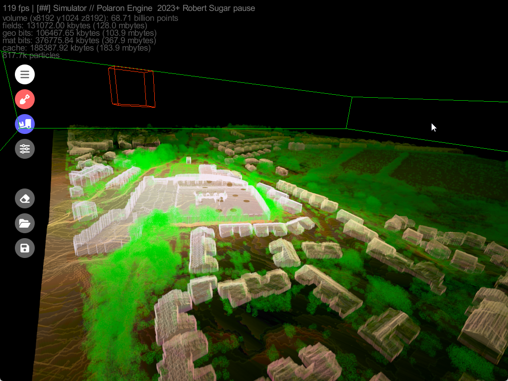
Behind the visuals and interfaces lies a cutting edge volumetric database – that we believe is the fastest of it’s kind – which permits real-time sensor data to be displayed (e.g. Lidar / Stereo Cameras / etc) this speed is a key feature of Polaron – since the same speed permits huge datasets to be ingested, processed, updated and modelled on. This scale allows us to process the entire OSM DB of the UK in under 2 minutes – which then stores the entire UK @1m2 resolution.
We can then load and instantiate these tiles in milliseconds and refresh or add additional data to these in real-time. Such performance and database size requires lightning fast data sanitisation and error checking – which we accomplish with a proprietary error checking tool – since parsing data isn’t sufficiently robust and prone to errors and failures. We can consequently place tolerances on this too – permitting us to use imperfect data or data the contains uncertainty – and even encode that into the volumetric data map – allowing partial or imperfect data to be used and quantified.
Semantic segmentation & Profiling via a Voxelised Spatial environment
Polaron features a number of Ai & ML tools – that allow for the semantic segmentation of a scene or map – e.g. to find roads, shapes or patterns. This allows you to ingest volumetric data and tag it (or inherit annotated data from other tools) allowing you to build up an object recognition database and apply properties to these – which augments the simulation.
E.g. Detect all the stairways, benches, or platforms within a scene and model how they are used and utilised. Additionally we can import most objects into Polaron and allow users to apply values to them – including phone based scans, Lidar maps and even Volumetric Neural Models (such as NeRFies)
API interoperability and part of a system of systems – from flat data to simulation & insight
art of the challenge of Public Transport lies in the need to tie into other systems and networks – it’s therefore part of our larger efforts to produce an API portal with a simple and easy to use user interface as well as supporting mobile scanning – to permit interoperability with other systems and engage a larger audience of staff, sensors and even the public to add and help map the environment – be that the basic sensors on a phone – through to emissions monitoring and even pulling in thermal data from LEO to build a picture of the environment, consider passenger safety and provide a mechanism for feedback. Ultimately this is the basis for driving preferable customer behaviours and producing the intelligence to alter customer and commercial behaviours to drive better operational practices, plan changes and evaluate impacts and help to decarbonise the network and meet NetZero targets for both safety and combatting climate change.
Emerging &
Current Capabilities
Part of the desire to seek further investment is to allow us to continue to focus on the core simulation product, whilst allowing other parts of the team to focus on interoperability and integrations – since this is the common pain point to adding and removing data.
Whilst the gaming pathway ultimately generates an intuitive user interface and we can already expose APIs and feeds in the system, we want to make this more robust to allow Polaron to become a platform and ultimately a marketplace.
Update models and predictions as fast as the sensors can pass the data to Polaron.
Allowing you to quickly respond to events and new data and build in events and logic to drive real-time predictions.
Playback or scrub through time to see how events occurred or developed
Move beyond the snapshot – and simulate real environments over time – allowing simulation to inform junctures and inflection points.
Real-time based on business rules or logic that you set – e.g. predicted overcapacity, delays, etc.
Modelling, planning and simulation becomes truly effective when near instant feedback can be achieved. Once a simulation has been configured and tied into live data – you can set alerts to trigger prompts or even actions. This lets the simulations interface into real-world events, providing insights and potentially the ability to quickly review and plan, or assess the mitigation efforts or response.
Explain machine insights and tailor them with human factors to augment human decision making.
Simulation and even AI insight can be mapped and applied – allowing greater transparency in the data and validated against real sensor input.
By modelling the output of an ML model versus the ground truth, it becomes possible to develop validated models and simulations in support of ML, Ai and Research.
Scaling up the service and leveraging the cloud
Polaron was developed to run on COTs hardware (high end consumer GPUs & CPUs) however when the power of the cloud is applied – the complexity and number of networked simulations can expand exponentially.
This brings a huge number of benefits – from scalability to expandable resources and a PAYG model or subscription service.
This in turn brings a lot more interoperability and benefits to both businesses and end users.
Automatic data updates
Automate the ingestion of GIS / EOS data, bulk imports or just sync to our daily OSM refresh.
This is the stepping stone to a marketplace and interoperability with other marketplaces such as AWS and ESRI
Cache and stack data
Polaron is designed to run on COTs hardware – which has forced us to adopt highly efficient processes to reduce the cost to run.
Some processes can be cascaded up – allowing multiple instances to scale and provide collective insights beyond the compute limits of a single instance.
Works where you work – Browser Access.
By allowing browser based access for multiple users, you can work where you work (WFH!) and model on the go.
This approach also allows for a plug and play and SaaS model to be supported.
Ultimately we want to expand on the multi user work undertaken in 5G-Victori using Web-RTC connecting multiple users and even streaming data to Unity AR.
Hybrid en-prem, edge and cloud solution
The ability to network and synchronise larger networks of Simulations and services and still offer an edge based solution, provides a high degree of resilience and security for spatial applications.
This means we can offer LAN and edge based insights, whilst still offering the capability of the cloud.
Arrange an investor meeting with us.
You made it this far – so hopefully you’re keen to have a conversation with us.
Please fill out the form and we can agree a preliminary call – followed by an mNDA.
We’re always delighted to speak to prospective investors and can provide an investment deck on demand once we’ve verfified your request.